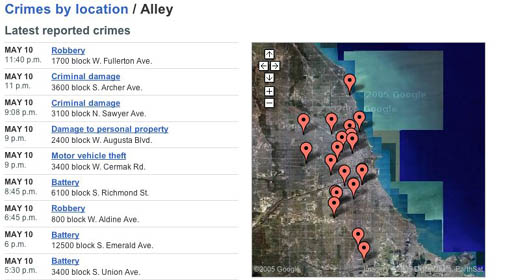
chicagocrime.org, the best use of Google Maps I’ve seen to date, has been making the web rounds over the past week. It generates maps using information scraped from Citizen ICAM, a public portal to the Chicago Police Department’s database of reported crime. You can view by type of crime, street, date, police district, location type (i.e. alley, ATM, residence etc.), or a map of the whole city.
This is the latest in a series of living documents that have sprung up recently – web spaces tied by a thousand strings to real, physical places. I can imagine chicagocrime being integrated into a larger Chicago area web hub, or aggregator. Ideally, these hubs (see here and here) will combine the conviviality of the blog, the utility of craigslist, the diversity of Flickr or ourmedia, and the collective vigilance of citizen journalism. Other recently launched intitiatives of note are Bayosphere (“…of, by and for the Bay Area) and mnspeak.com (“twin cities: all day, all night”). The more people participate, the truer the picture of that place at that time. Are we moving past the primacy of the editor? Or will editors prove more important than ever before?
if:book
A Project of the Institute for the Future of the Book